The climb is tough but the views are worth it.
How do you spend your free time? How do you find peace?
Where do you go when you want to clear your thoughts, move your body or just experience true natural beauty?
We live on an Island people dream of visiting. In a province abundant in isolation, natural wonders, and back country hiking as well as local hikes and walks. If you're wanting to get out there and try this amazingly therapeutic and rewarding activity - I highly suggest - get a partner and get hiking. Even if that partner is your dog.
I am in no way an expert hiker but I’ve had many people ask me
to write up a blog on some of the hikes I have done. So here goes just a little
overview on fairly accessible and moderate hikes to do in our British Columbia backyard.
Always keep in mind that all skill levels are different.
Sometimes walking a city block isn’t easy, sometimes walking a city block is a mountain - but that is okay. When I say a hike is moderate or not difficult I mean I am not
requiring a lot of gear or anything outside of the basic planning. These are short or afternoon - or day
to over night hikes - that I will include here.
When you are planning a hike there are quite a few things to take into consideration (especially if it isn't a hike you have done before)..
Firstly, make sure to research if it’s going to be beautiful so you can get real excited, then while you’re
real excited check off the safety and planning list so that you don’t forget to do a few key things:
(trust me, I’ve learned from my own mistakes by not doing these things – it’s
not worth it).
1. Track your hike and give yourself extra time. This includes mapping out your hike route/distance, the skill level of hike – is it easy, moderate, or difficult.
2. Pick the right shoes for the level of hiking.
3. Pack light but pack an emergency kit (including an emergency blanket, map, app or compass, whistle and lighter/I also always bring an emergency kit with items for my dog incase she gets injured along the way) and make a plan for if you’re injured (mild or severe). BRING WATER. Know where there is and isn't fresh water located on your route. If you can – bring a spot or GPS tracker – this is “ideal”, if not, have an emergency plan on the ground (at home) if you don’t return at a certain time.
LET SOMEONE KNOW WHERE YOU’RE GOING
4. Headlamp if something happens and you end up hiking in the dark - you'll wish you had it.
5. Always, pack a snack and again water (I learned this the hard way many years ago,
from experience very early on, even shorter day hikes this is important). Knowing the difficulty of your hike ahead of time can help prepare you for what you will need to replenish your body to complete your trip / hike back out.
6. How are you going to get there? I've had a few hikes that
I've attempted to get to with my AWD without luck leaving me to walk up the
logging road adding on extra KM and extra time, luckily I have almost always anticipated this in my pre trip plan!
7. Assess the weather prior to leaving (and pick your clothing appropriately), as well as the elevation of your hike as rain on the ground might mean snow in the skies. It’s easy to get disoriented and lost if you end up in a snow storm. Pack sunscreen/Hat/Layered clothing depending on your weather planning/time of year.
8. Know your fire warnings. Is there a total fire ban? Are you
in a park that does not allow fires even when there isn't a ban? Look for an established fire ring if there is no obvious signage.
9.. Hike with a buddy or at least with a dog if possible.
10. Be aware of your terrain, bluffs and edges. I've "posed" for some photos where it looks like I am on the edge of the world - keep in mind I am terrified of heights and there's ground below me that you CANNOT SEE. Never put yourself - and the SAR crew in danger for something unnecessary.
11. BEAR awareness. Be aware of and safe about ALL wild life – you are heading into
their home – bring bear spray/bells – and be clean and food smart. Use bear cashes, cook away from your camp, and wash your dishes. This is cougar, bear and wolf country on Vancouver Island and you don't want to attract anything. All those scary animals aside - if you even keep toothpaste in your tent you're at risk of mice chewing through your gear to get to it. For safety of yourself and your gear it's better to store it all far away.
12. Pack it in and pack it out .. This includes your own dirty toilet paper ya'll. This beautiful back country ain't your outhouse.
Now to enjoy some beautiful BC hiking photos


Menzies Mountain
Located north of Campbell River, this is the MOST romantic and beautiful sunset lookout in town - I swear it. It's a great calf burner as it's a steep grade logging road in. However, you can totally cheat and drive to this great little bluff. Beyond this height you can continue up this logging road even further for a sunset view of the surrounding islands and coastal mountains on the opposite side (this one you have to hike - or quad in to).

This West Coast Vancouver Island this hike is an approximately 5.5 km; it is an absolute uphill grind but the view is worth it. You must prebook your water taxi to
Meares Island and plan your day taking in the salty air and stunning views of
our backyard (post COVID as the island is currently closed to non residents).


Emma Lake
This is in my TOP 2 FAVOURITE day hikes ever. This one is on the beautiful Sunshine Coast located near Powell River area and it's absolutely my favourite view. This is known as the natural stair master and the views are worth every single painful step. Here's what I didn't know: there's a user maintained hut at the top (stay the night folks) also the bugs are killer in August. We couldn't even stop to take a break (or enjoy the view).
This road is "high 4x4" access only / partial quad access. We were left hiking the logging road which added on some SERIOUS time and distance but as you can see it's stunningly worth it.

The Chief
Again, I'm not remotely at risk in this image. I love this hike. There are a million + 1 stairs and every one literally brings you to heaven. It is stunning. This mainland hike is one of my fav.
I've managed to fit it in many times over the years. It's short and sweet to
the first peak. And by sweet I mean deadly on the glutes but is pretty hiker
friendly if you enjoy stairs and ladders.

Joffre Lakes
Joffre Lakes is another mainland backyard treasure. Head out
to Whistler (post pandemic) for these beautiful icy blue lakes. Unfortunately, it is absolutely full of people but that's part of sharing this beautiful
earth. These glacier lakes are a bit of an afternoon hill climb to get to but
again, they're crazy worth it. This is an approximately 10 km well used, UP
HILL, easy terrain hiking trail.

Back to the island: Mount Tzouhalem is an island beauty. There are so many
trails to hike and mountain bike. It's pretty easy to get to if you put it into
google maps and let it take you to the trail head parking lot. You could spend all after exploring these easy incline trails and have lunch with a view at the top.


Cox Bay Look Out
Another West Coast Gem. I have hiked this peak too many times to count and it really
never gets old. This is such a beautiful view point. This one is best left to
high cloud cover or sunny day so that you can get the clear day visuals. It's a short
hill hike (full of muddy bogs and technical roots).
The Wild Pacific Trail is one of my favourite West Coast
Hikes. It is wheelchair friendly, accessible from many points, it is walkable,
runnable, and can be short (directly from your car at the AmphitriteLighthouse
Point), or it can be long.. Either way the terrain is easy and the views are spectacular the entire time. There's a 2.6 km loop near the light house or you can weave through
town and follow the path 5 km north of Big Beach

These gorgeous views are about half way up Mount Ozzard in
Ucluelet. This is a steady incline up an old logging road for some serious
stunning views of the coastal islands and communities. It's a fairly accessible
and easy footpath but it is all up hill.
{These last 3 hikes are located in small towns that how many tourists and tourism opportunities however, they do not have the medical services to support a COVID 19 outbreak and have asked everyone to stay away at this time when possible}


Bedwell Lake is a 15 km out and back grind. I have done this trail a couple times to baby Bedwell, and Bedwell Campsite (overnight). This trail is a serious uphill battle with high stairs made of logs, switch backs, and big rocks. There are many ladder like staircases, board walks, and other ways of seriously GAINING elevation. It is breathtaking nestled into the mountains with a lake for swimming and beautiful views, it is however quite buggy in mid summer. Day 1 : completely fogged in. Day 2 : warm and beautiful lake swim morning.

Beaver Lodge Trails
Beaver Lodge is a trail network right
in the heart of Campbell River. It is easy terrain, minimal elevation change and is (on the main artery)
accessible by wheelchair or stroller as well. There are side trails that offer a bit more
uneven terrain and many options for mountain biking, running, and dog walking
where you're less likely to bump into other people. We frequent these massive networks as they are very dog friendly.

The Campbell River Lookout.
This hike is a bit more difficult due to the terrain. It is
short and a great morning or afternoon hike. However, as you start your ascent you'll find steep switch backs that lead
you to rock bluffs where you'll use a series or ropes and chains to assist your
climb. They are only short sections of the overall hike, however agility and
grip are two things you'll need a bit of along with endurance. This, though very short and close to town, is a perfect example of a hike that rain on the ground means snow in the skies - even in March.

The Canyon View Trail
The Beautiful, local to Campbell River, and perfectly
situated river loop.. This is a relatively easy 4.5 km hike however, it is not
wheelchair accessible as it has many roots, rocks, and stairs involved. It is
surrounded by beautiful rain forest and you can access it from either end. The
bridge, parking lot across from Quinsam Campground, or the BC Hydro station
parking lot. You will likely see eagles, deer, salmon and in certain seasons
black bear. We find ourselves here 5 days a week some seasons!

Ripple Rock
This is a local hike north of Campbell River. It is an 8 km
in and back trail with roots, bridges, stairs, and rocks, bluffs, as well as
beautiful view points. It has been upgraded in recent years making it much more
accessible however it's still a great option for a morning or afternoon day hike with a
stunning view. The up and down terrain make it feel a bit easier than other
options (Lookout trail). However, the mileage is a bit longer in the end.

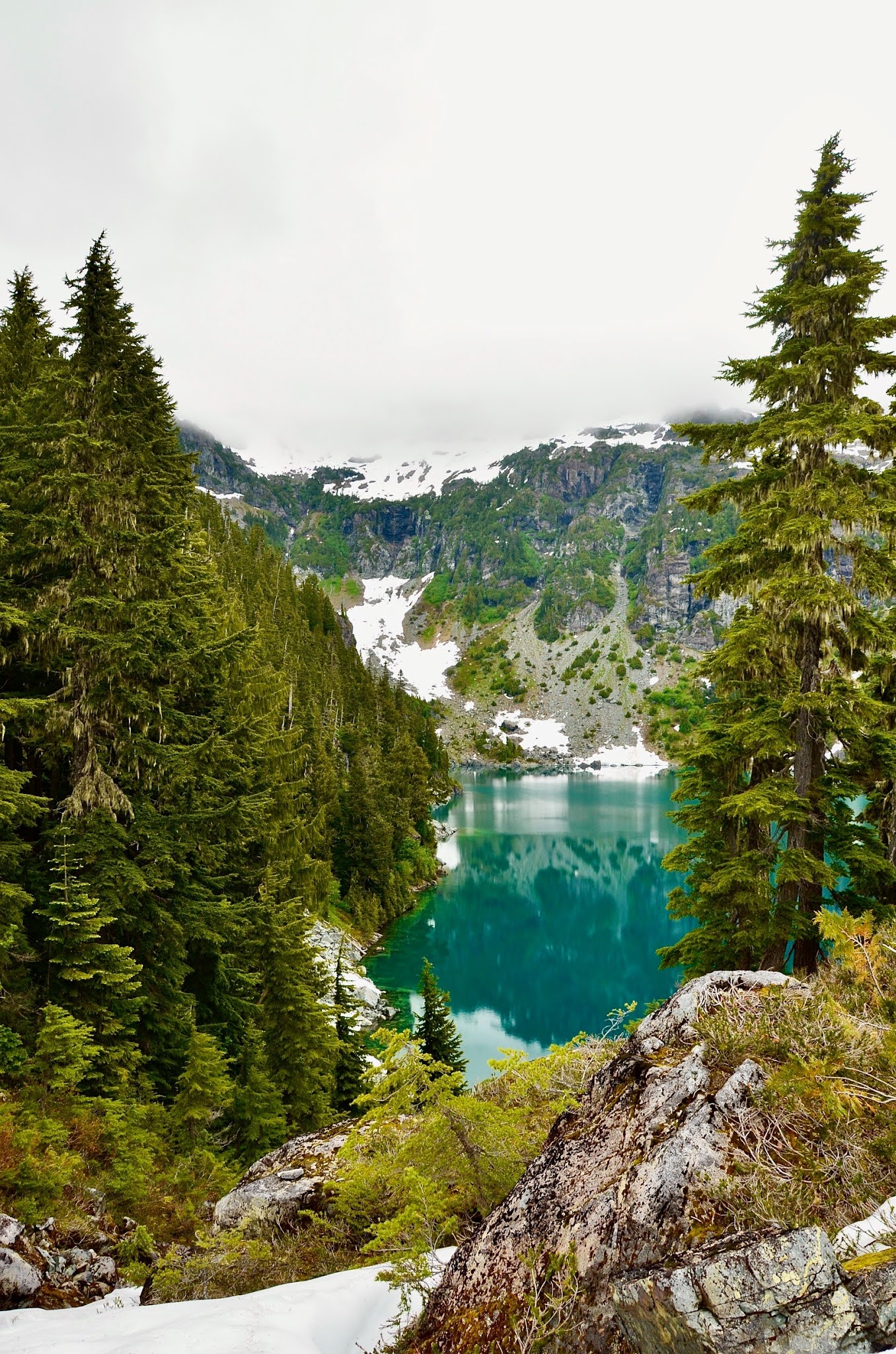
Landslide Lake
Yep, another ice cold glacier lake. This a 22 km hike along
the elk river. There are a few water and bridge crossings but it's a relatively
flat hike that offers two separate camp areas so you can actually ditch your
overnight pack quite early in your trek (also very doable as a day hike). This trail peaks in height at the end
which brings you up to the lake where the bugs are waiting to eat you alive.
It's sadly the truth. There's a
trail around the lake to Berg Lake that gives a better view (however we did not find it on this trip as the brush was quite grown in at this time of year)

Century Sam
Get ready to hike into some elevation and it'll all be so,
so worth it. This hike is only accessible on weekends as the entrance is on
forestry land - and has very strict gate closures. That also means if there are fire bans in place it is likely
locked to the public. This glacier lake is clear
and blue but better yet continue along the path above the lake to see the
beautiful glacier caves. It is not recommended that people enter the caves as
without proper training, it is impossible to know the capacity of ice and snow
and the caves could collapse. The hike itself has difficult terrain as it is grown over and almost impossible to see your footing at times. Otherwise it's a relatively moderate out and back trail that should take a morning or afternoon.

Elk Falls Waterfall and Suspension Bridge
This backyard tourist attraction is my favourite on icy and rainy days, but it's beautiful any season. The trail is flat and well maintained. It's a quick in and out which could be stroller or wheelchair accessible to the top of the stairs only. It's at it's best when heavy rain fall has occurred and high water flows are being outputted through the dam.

Havenwood Park
Colwood has this stunning little park and trail network
through beautiful forests right close to the main highway. It takes minutes to
get to and these stairs are great for the cardiovascular system if you're down island.

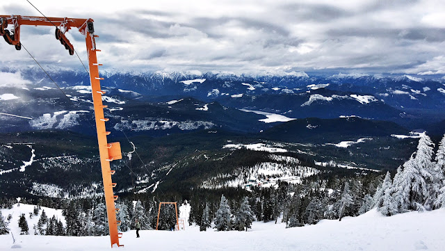
Mount Cain
I am yet to hike Mount Cain in the summer but I have heard
the trails and views are incredible. The drive up alone is stunning. Take your
snow shoes out for some great winter hiking into the back bowl and see stunning
views and marshmallow trees. The drive in in winter is only accessible for
vehicles with chains as it is not regularly plowed or salted.

Rebecca Spit
This is a light walk at sea level. But a beautiful local one that shouldn't be
left out. Rebecca Spit (Quadra Island) is a stunning ocean side loop
that is accessible to all and should definitely be on your summer bucketlist. While at this spit - look for this guy - built locally by
Drifted Creations.

Kettle Valley Rail Trail
This is such a stunning trail option. It is great for hiking
or biking. The biking option starts from Myra Canyon in Kelowna and ends 80 km
later in Penticton. I biked the Myra Canyon end and on a separate day hiked the
Penticton end (seen above). I'm yet to do the entire journey (but it's on the
very long list). This trail is so well maintained and is a down slope the
entire way if you start at Kelowna. It is wheelchair accessible and has so many
stunning views from either end. The Penticton end has wine, just saying.

Othello Tunnels
I love this little spot. I have been back here in all the
seasons. It's another great wheelchair/stroller friendly hike or bike option.
These old train tunnels are now gravel and board walks and they're SO
beautiful. If you're in the Hope area - put this on your LIST now!!!

Chinese Mountains
Chinese Mountains are a steady uphill climb, but a
relatively easy up hill hike as the terrain is mostly flat/shale rock and there
is no climbing chains, ropes, or ladders, and is located on Quadra Island.

I think this is still totally my top day hike on Vancouver Island. Via judges route this is a 6.0 km out and back hike. It doesn't sound long but this is a 1,000 m elevation gain in 3 km. It's a bit on the busy side, as you can only access it two days a week however this uphill grind opens up to these absolutely incredible views and leave you breathless (from the steady incline and stunning mountain views).


Trout Creek
This beautiful swimming hole and short hike is just north of Campbell River. It is off a main logging road so is accessible to any vehicle. If you follow the trail up to the right of the falls it continues further for a view of 5 water falls.

Myra Falls
Though a very long and winding drive for this short hike in waterfall, it's still worth being on the list of things to see and do when visiting (or living) in Campbell River / Strathcona Region. There are many other short hikes in the area that can fill the entire day with healthy hobbies and beautiful views.


Tin Hat
(It is also accessible by quad to the top or mainly by vehicle with a short 45 min walk IF you wanted to go that route).

Della Falls
Della Falls is a challenge to get to and absolutely completely worth it. To reach this trailhead you have to boat / or paddle across Great Central Lake where you'll start your trek in the absolute worst mosquitoes of life. Again. It is worth it. It's a long first day, 17 km to set up camp at the base of the falls. From below they're beautiful but not spectacular, you cannot get the true appreciation of this 400m water fall ( Vancouver Island’s tallest). Day 2 hike to Love Lake is where all the views take place. Going early in the season is key to this hike so that you in fact get to see a water fall. Fresh water sources are abundant on this hike.


Lindeman Lake

Oyster River Trail
A local treasure and one of my favourite gentle walks. Start here at the old pub, the trailhead behind Discovery Foods, or at the old Salmon Point Pub site. This trail is flat and easily accessible to all, it is also usable all year round. Great for kids and pets!!


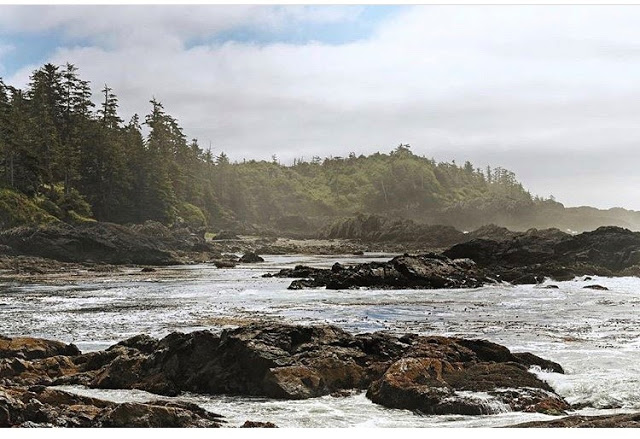
San Josef Bay

Cumberland Forest / Pot holes


Helen McKenzie
Helen McKenzie is an easy and accessible 8.5 km hike located in Paradise Meadows in Strathcona Park. Head to Raven lodge on Mount Washington and start your beautiful adventure through the mountain terrain with icy streams, mountain trees, lakes, wild blueberries, hungry Whiskey Jacks and other wildlife. This is also an amazingly stunning snow shoe in the winter, I highly recommend in both seasons. In the winter the signs with trail maps are deep under the snow but during the summer months there are many maps and many tent sites available for over night as well.

CruikShank
Cruikshank is a bit of a long stretch for the canyon view. Just over 20 km will wind you through streams, lakes and campsites on the way to these rock bluff views. Mount Washington and Paradise Meadows is abundant with hiking options. Some are wheelchair accessible and others offer a more challenging terrain. Camp, hike or swim through the whole summer and fall up here before the snow comes!


Crest Mountain


This hike is a beautiful little stream side trail network that weaves through the base of the malahat mountains and up to the old railway trestle. It's an easy hike that is great for a quick morning or afternoon.